
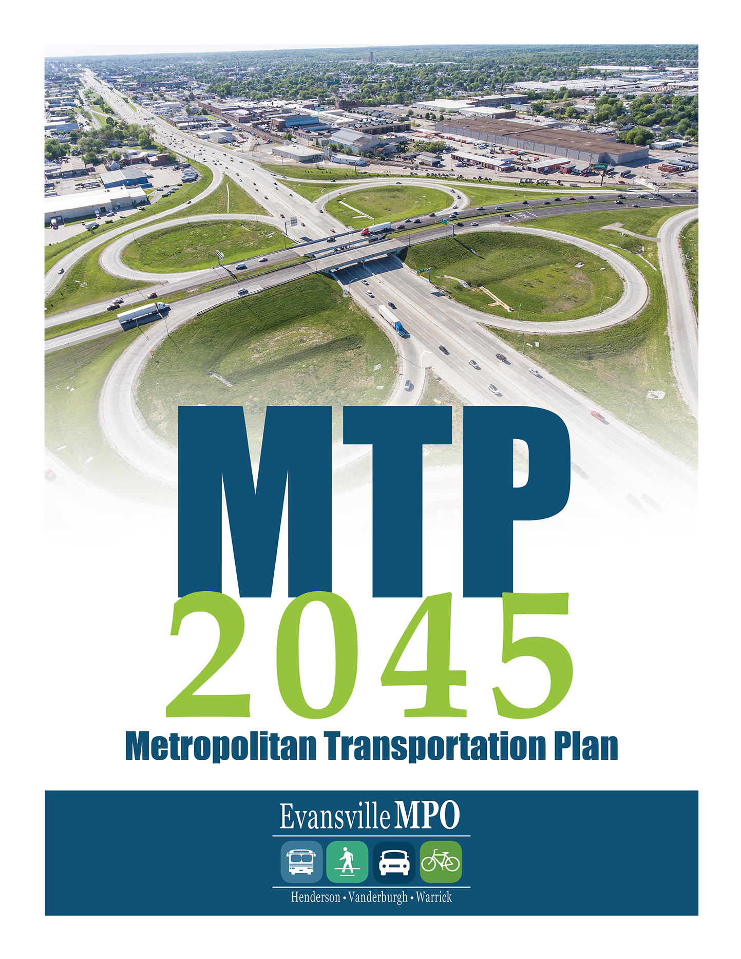
About MTP 2045
As the Metropolitan Planning Organization (MPO) for the Evansville-Henderson planning area, EMPO is required to conduct a continuing, cooperative, and comprehensive transportation planning process, with a 20-year horizon, that results in producing a Metropolitan Transportation Plan (MTP) and Transportation Improvement Program for the region.
The MTP is a long range planning document that identifies transportation deficiencies, policies, strategies and projects over the next two decades. It is updated on a four-year cycle. EMPO coordinates the development of the MTP with local, state and federal partners. The MTP makes the Evansville region eligible to receive federal transportation funding to improve, maintain and operate highways, public transit, bikeways, sidewalks, and related facilities. Transportation projects must be included in the MTP to be eligible to receive federal funding within the EMPO planning area. The MTP is also required to show Conformity with the IDEM’s State Implementation Plan for mobile source greenhouse gas emissions.
Planning Jurisdiction
The EMPO Metropolitan Planning Area (MPA) contains approximately 650 square miles in Indiana, including the City of Evansville, Vanderburgh County, Warrick County, and a very small area of eastern Posey County. In Kentucky, the Study Area encompasses approximately 440 square miles which includes the City of Henderson and Henderson County. With a population that exceeded 200,000 in the 2010 Census, the Evansville-Henderson urban area has been designated as a Transportation Management Area (TMA).
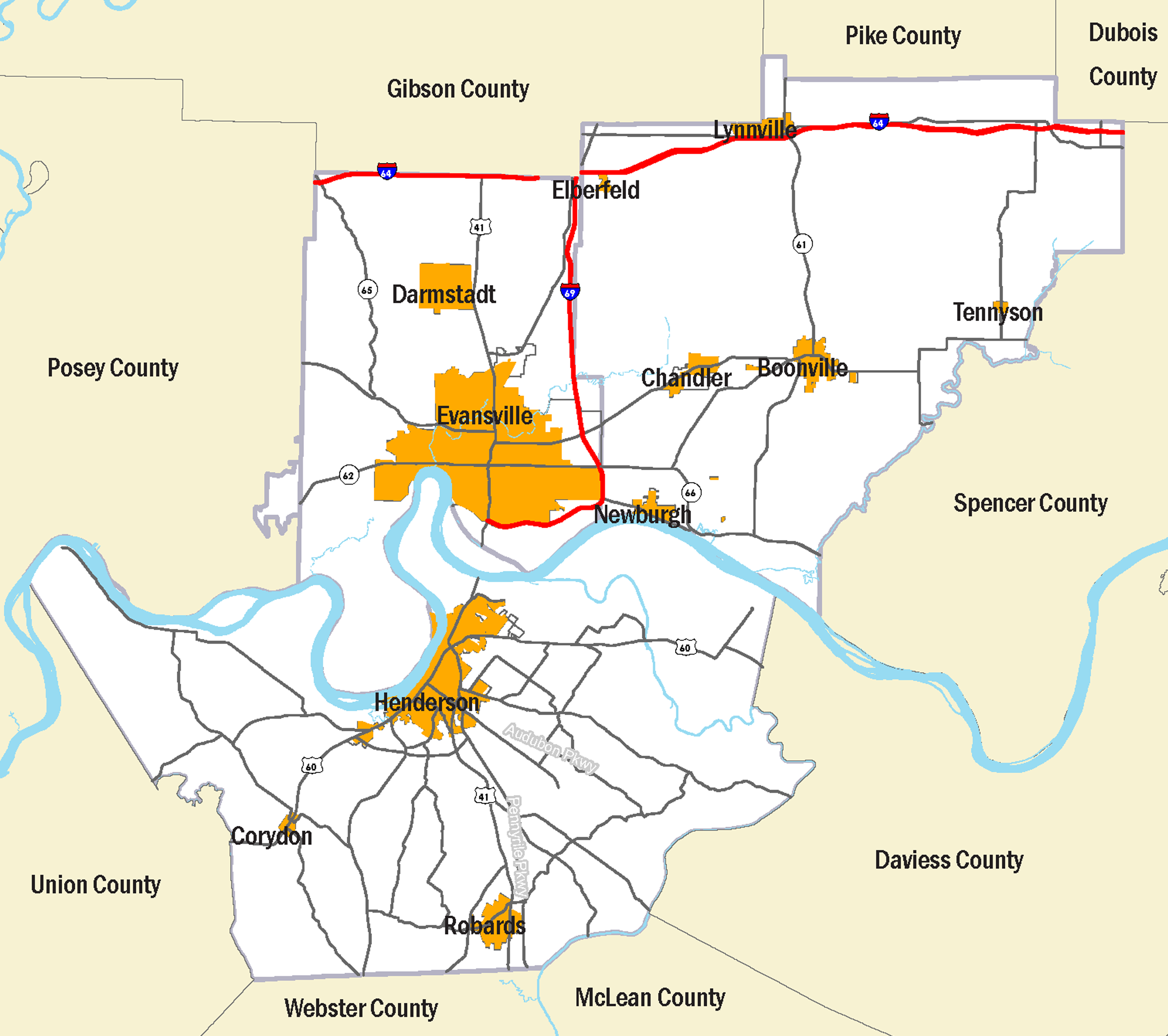
Planning Area Map
The Plan Includes
- Regional goals, objectives and performance measurements
- Socio-economic trends and their impact on transportation
- Evaluation of the current system and future needs
- Listing of eligible regionally significant transportation projects
- Evaluation of the future transportation system assuring that it will be fiscally balanced, meet federal requirements regarding air quality and social equity
- Implementation strategies
MTP 2019 - 2045 Projects
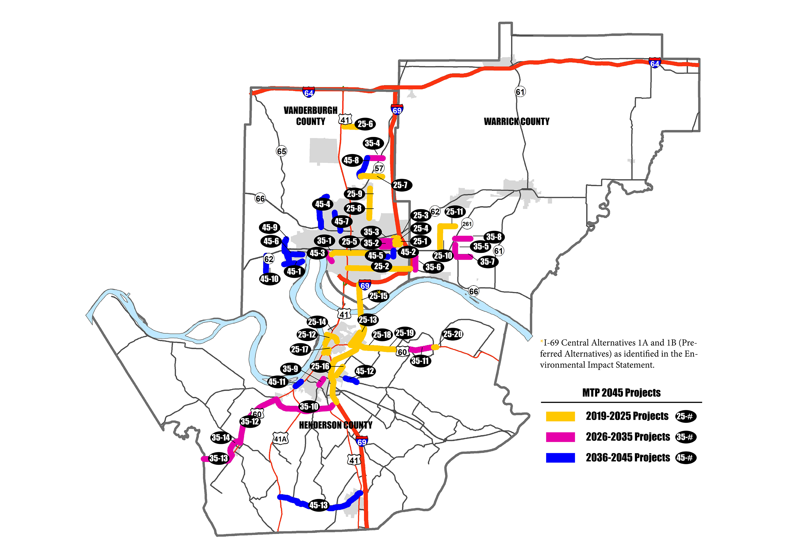
Projects Map
MTP 2019 - 2045 Project List
| MTP ID | Road | Limits | Type | Completed Between |
|---|---|---|---|---|
| 25-1 | Columbia St | Hirschland Rd to Cross Pointe Blvd | New | 2019 - 2025 |
| 25-2 | Covert Ave | US 41 to I-69 | Reconstruct (Road Diet) | 2019 - 2025 |
| 25-3 | Oak Grove Rd | Burkhardt Rd to Cross Pointe Blvd | Widen (5 Lns) | 2019 - 2025 |
| 25-4 | Vogel Rd | E of Hirschland Rd to Cross Pointe Blvd | New (3 Lns) | 2019 - 2025 |
| 25-5 | Walnut St | MLK Blvd to Vann Ave | Reconstruct | 2019 - 2025 |
| 25-6 | Baseline Rd | Husky Way to Old State Rd | Widen (TWLTL) | 2019 - 2025 |
| 25-7 | Kansas Rd | Petersburg Rd to Green River Rd | Widen (TWLTL) | 2019 - 2025 |
| 25-8 | Oak Hill Rd | Lynch Rd to Heckel Rd | Widen (TWLTL) | 2019 - 2025 |
| 25-9 | Oak Hill Rd | Heckel Rd to Millersburg Rd | Widen (TWLTL) | 2019 - 2025 |
| 25-10 | Bell Rd | High Pointe Dr to Telephone Rd | Widen (TWLTL) | 2019 - 2025 |
| 25-11 | Telephone Rd | Bell Rd to Fuquay Rd | Widen (TWLTL) | 2019 - 2025 |
| 25-12 | North Elm St | Watson Ln to 12th St | Upgrade | 2019 - 2025 |
| 25-13 | Wathen Ln | US 60 to City Limit | Upgrade | 2019 - 2025 |
| 25-14 | Watson Ln | Sunset Ln to Green River Rd | Upgrade | 2019 - 2025 |
| 25-15 | I 69 | Ohio River Crossing | New | 2019 - 2025 |
| 25-16 | KY 1539/Zion-Larue Rd | KY 351 to Kimsey Ln | Upgrade | 2019 - 2025 |
| 25-17 | US 41 - US 60 | Interchange Modification | Reconstruct | 2019 - 2025 |
| 25-18 | US 60 | Wathen Ln to KY 2183/ Holloway-Rucker Rd | Widen (4 Lns) | 2019 - 2025 |
| 25-19 | US 60 | KY 2183/Holloway-Rucker Rd to KY 1078/Baskett Ln | Widen (4 Lns) | 2019 - 2025 |
| 25-20 | US 60 | New Bridge over Green River at Spottsville | Replacement | 2019 - 2025 |
| 35-1 | Third St | Court St to Parrett St | Reconstruct | 2026 - 2035 |
| 35-2 | Virginia St | Green River Rd to Burkhardt Rd | Widen (TWLTL) | 2026 - 2035 |
| 35-3 | Vogel Rd | Green River Rd to Burkhardt Rd | Widen (TWLTL) | 2026 - 2035 |
| 35-4 | Boonville-New Harmony Rd | Petersburg Rd to Green River Rd | Upgrade | 2026 - 2035 |
| 35-5 | Casey Rd | Vann Rd to SR 66 | Widen (TWLTL) | 2026 - 2035 |
| 35-6 | Epworth Rd | SR 662 to Lincoln Ave | Widen (TWLTL) | 2026 - 2035 |
| 35-7 | Lincoln Ave | SR 66 to Anderson Rd | Widen (TWLTL) | 2026 - 2035 |
| 35-8 | Oak Grove Rd | SR 261 to Anderson Rd | Widen (TWLTL) | 2026 - 2035 |
| 35-9 | Atkinson St | KY 136 to KY 812/Clay St | Reconstruct | 2026 - 2035 |
| 35-10 | KY 425/ Henderson Bypass | US 60 to I-69 | Widen (4 Lns) | 2026 - 2035 |
| 35-11 | US 60 | KY 1078/Baskett Ln to Green River Bridge | Widen (4 Lns) | 2026 - 2035 |
| 35-12 | US 60 | Corydon to KY 425/Henderson Bypass | Reconstruct | 2026 - 2035 |
| 35-13 | US 60 | Waverly, KY to Corydon, KY | Reconstruct | 2026 - 2035 |
| 35-14 | US 60 | City of Corydon Bypass | New | 2026 - 2035 |
| 45-1 | Broadway Ave | City Limits to Barker Ave | Reconstruct | 2036 - 2045 |
| 45-2 | Burkhardt Rd | Lincoln Ave to SR 66/Lloyd Expy | Widen (5 Lns) | 2036 - 2045 |
| 45-3 | Claremont Ave | Red Bank Rd to Barker Ave | Reconstruct | 2036 - 2045 |
| 45-4 | Kratzville Rd | SR 66/Diamond Ave to Darmstadt Rd | Reconstruct | 2036 - 2045 |
| 45-5 | Lincoln Ave | Green River Rd to Newburgh Rd | Widen (TWLTL) | 2036 - 2045 |
| 45-6 | Red Bank Rd | Broadway Ave to SR 62/Lloyd Expy | Reconstruct | 2036 - 2045 |
| 45-7 | Stringtown Rd | SR 66/Diamond Ave to Mill Rd | Upgrade | 2036 - 2045 |
| 45-8 | Petersburg Rd | Boonville New Harmony Rd to Kansas Rd | Reconstruct | 2036 - 2045 |
| 45-9 | Red Bank Rd | N of SR 62/Lloyd Expy to Upper Mt Vernon Rd | Reconstruct | 2036 - 2045 |
| 45-10 | Schutte Rd | SR 62/Lloyd Expy to Broadway Ave | Reconstruct | 2036 - 2045 |
| 45-11 | S Main St | Drury Ln to Yeaman Ave | Reconstruct | 2036 - 2045 |
| 45-12 | KY 351 | Denise Dr to Bishop Ln | Reconstruct | 2036 - 2045 |
| 45-13 | KY 416 | US 41 to US 41A | Reconstruct | 2036 - 2045 |
Conformity
About Conformity
Transportation Conformity is required under Section 176(c) of the Act to ensure that Federally supported highway, transit projects, and other activities are consistent with (conform to) the purpose of the approved State Implementation Plan (SIP). Transportation Conformity applies to areas that are designated nonattainment and those areas redesignated to attainment after 1990 (maintenance areas), with maintenance plans developed under section 175A of the Act for the following transportation-related criteria pollutants: Ozone, particulate matter (PM 2.5 and PM 10), carbon monoxide (CO), and nitrogen dioxide (NO 2). Conformity to the purpose of the SIP means that transportation activities will not cause new air quality violations, worsen existing violations or delay timely attainment of the relevant National Ambient Air Quality Standards (NAAQS). The Federal Transportation Conformity regulations (Federal Rule) are found in 40 CFR part 93 subpart A, and provisions related to conformity SIPs are found in 40 CFR 51.390.
Transportation conformity is being established for the Metropolitan Transportation Plan (MTP) 2045 and the FY 2022-2026 Transportation Improvement Program (TIP) adopted by the Evansville MPO Policy Board. The conformity is needed as a result of a recent decision from the United States Court of Appeals for the District of Columbia Circuit in South Coast Air Quality Mgmt. District v. EPA (“South Coast II,” 882 F.3d 1138), which struck down portions of the 2008 Ozone NAAQS State Implementation Plan Requirements Rule concerning the Ozone National Ambient Air Quality Standards (NAAQS) as well as the anti-backsliding requirements associated with the revocation of the 1997 Ozone NAAQS.
Areas such as Vanderburgh and Warrick Counties that were maintenance areas for the 1997 Ozone NAAQS at the time of revocation and are designated as attainment for the 2008 Ozone NAAQS, have not been required to make transportation conformity determinations for any Ozone NAAQS since the 1997 Ozone NAAQS was revoked in April 2015. Under the recent court decision, these areas, referred to as orphan areas rather than non-attainment or maintenance areas, necessitate new regional conformity determinations.

Conformity Area Map
The components of the conformity determination include
- Interagency Consultation
- Public Involvement
- Latest Planning Assumptions and Emissions Model
- Fiscal Constraint
Effective transportation planning requires an organization with a regional focus and the ability to operate independent of city, county or state lines.
Contact Us
Evansville, IN
Phone: 812 436 7833
Fax: 812 436 7834
Email: comments@evansvillempo.com
Social:
2015 © All Rights Reserved. | Design by tecKEY | ![]()